
Fichier:Map of the Territory of the Parisii.svg

Taille de cet aperçu PNG pour ce fichier SVG : 424 × 600 pixels. Autres résolutions : 170 × 240 pixels | 339 × 480 pixels | 543 × 768 pixels | 724 × 1 024 pixels | 1 448 × 2 048 pixels | 744 × 1 052 pixels.
Fichier d’origine (Fichier SVG, nominalement de 744 × 1 052 pixels, taille : 148 kio)
Ce fichier et sa description proviennent de Wikimedia Commons.
| Description |
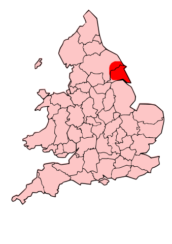
English: A map showing the territory of the Dobunni tribe overlayed in red in the context of the modern county boundaries of England and wales Image depicting the Celts of North and Midland England, pre-Roman Britain times. I created this myself, under the guidance (to find location of them) of Roman-Britain.org |
| Date | (UTC) |
| Source | |
| Auteur |
|
.svg)
.png)
| Cette image a été retouchée, ce qui signifie qu'elle a été modifiée par ordinateur et est différente de l'image d'origine. Liste des modifications : Modified county map with overlay of territory of parisii. L'image d'origine se trouve ici : England Celtic tribes - North and Midlands.png:
|
Ce fichier est disponible selon les termes de la licence Creative Commons Attribution – Partage dans les Mêmes Conditions 3.0 (non transposée).
- Vous êtes libre :
- de partager – de copier, distribuer et transmettre cette œuvre
- d’adapter – de modifier cette œuvre
- Sous les conditions suivantes :
- paternité – Vous devez donner les informations appropriées concernant l'auteur, fournir un lien vers la licence et indiquer si des modifications ont été faites. Vous pouvez faire cela par tout moyen raisonnable, mais en aucune façon suggérant que l’auteur vous soutient ou approuve l’utilisation que vous en faites.
- partage à l’identique – Si vous modifiez, transformez, ou vous basez sur cette œuvre, vous devez distribuer votre contribution sous la même licence ou une licence compatible avec celle de l’original.
Journal des téléversements d’origine
This image is a derivative work of the following images:
- File:Map_of_the_Territory_of_the_Dobunni.svg licensed with Cc-by-sa-3.0, GFDL
- 2009-10-13T19:47:34Z Jpb1301 744x1052 (151192 Bytes) {{Information |Description={{en|1=A map showing the territory of the Dobunni tribe overlayed in red in the context of the modern county boundaries of England and wales}} |Source=*[[:File:Map_of_the_Territory_of_the_Dobunni.sv
- 2009-10-13T17:38:36Z Jpb1301 744x1052 (151194 Bytes) {{Information |Description={{en|1=A map showing the territory of the Dobunni tribe overlayed in red in the context of the modern county boundaries of England and wales}} |Source=*[[:File:Map_of_the_Territory_of_the_Cornovii_(
- File:England_Celtic_tribes_-_North_and_Midlands.png licensed with Cc-by-sa-3.0
- 2009-07-29T23:43:34Z Thomas Gun 296x495 (27459 Bytes) == Summary == {{Information |Description=Image depicting the Celts of North and Midland England, pre-[[Roman Britain]] times. I created this myself, under the guidance (to find location of them) of [http://www.roman-britain.o
Téléversé avec derivativeFX
Historique du fichier
Cliquer sur une date et heure pour voir le fichier tel qu'il était à ce moment-là.
| Date et heure | Vignette | Dimensions | Utilisateur | Commentaire | |
|---|---|---|---|---|---|
| actuel | 16 octobre 2009 à 22:16 | | 744 × 1 052 (148 kio) | Jpb1301 | {{Information |Description={{en|1=A map showing the territory of the Dobunni tribe overlayed in red in the context of the modern county boundaries of England and wales}}Image depicting the Celts of North and Midland England, pre-Roman Britain times. I |
Utilisation du fichier
Les 7 pages suivantes utilisent ce fichier :
- Parisii (Grande-Bretagne)
- Discussion:Parisii
- Discussion:Parisii/LSV 17690
- Wikipédia:Le saviez-vous ?/Archives/2020
- Wikipédia:Statistiques des anecdotes de la page d'accueil/Visibilité des anecdotes (2020)
- Wikipédia:Statistiques des anecdotes de la page d'accueil/Visibilité des anecdotes (2020)/2020 02
- Projet:Aide et accueil/Twitter/Tweets/archives/février 2020
Usage global du fichier
Les autres wikis suivants utilisent ce fichier :
- Utilisation sur ca.wikipedia.org
- Utilisation sur cy.wikipedia.org
- Utilisation sur en.wikipedia.org
- Utilisation sur fi.wikipedia.org
- Utilisation sur la.wikipedia.org